This list of features gives you an overview of what Kiosk does and how it does it. Click on some items to see screenshots and read more detailed description. Starred items are killer features we really think you should know more about!
In the Recording App:
The recording app, accessed through FileMaker Go on the iPad, is where you make your field records. Its user interface is tab-structured. This might look less sleek and modern than a scrolling interface but believe us, it works better for making sure your team records all the right stuff.
Before we look at specific features, one is super general:
- images – nearly every type of record in Kiosk includes the ability to make images related to it. You can make images from within Kiosk itself, or using other apps on the iPad. You can bring images made with other devices entirely into the recording, as you can see in the site map on the homepage below.
The home page:
When you log in, you will see something much like this:
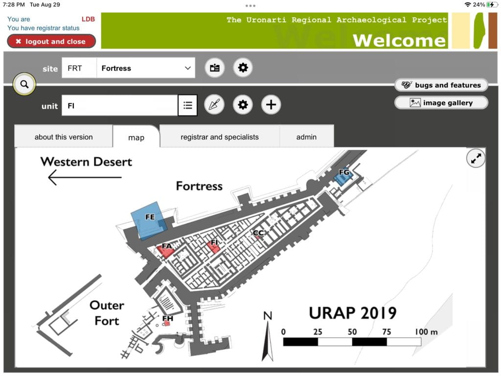
Sites
- create new sites in the same database
- upload a map that will be your homepage image for a site
- take notes on sites to record observations or progress not bound to a unit
- add images to site notes
Units/Trenches/Operations/Areas
Call them what you will, from open areas to shovel pits, archaeologists work in geographically bounded units. You can pick the name, but the recording tabs will be largely similar across projects.
Click on the trowel button to go to an existing excavation unit or the feet to go to an existing survey unit.
Click on the plus button to create a new unit and define its type.
Excavation units:
- unit-level description: purpose, opening and closing dates, supervisor
- narrative/images
- list of contexts/loci/stratigraphic units and a preview of information
- list of collected materials/finds from the unit
Contexts/Stratigraphic Units/Loci
- observation tab to input context information basics (opening and closing dates, description, context type, supervisor, etc)
- special details determined by context type, such as graphic soil sorting chooser for deposits
- measurements
- interpretation – we separate observation and interpretation to help your team make the best notes. Here you can also tag contexts to create meaningful groups of contexts for analysis.
- photos
- context relations
- collected materials
- choose transect or total collection/observation
- note conditions
- description and images
- collect or observe objects per transect, with team members assigned to transects
- create features or assign previously created features to the survey unit
Special stuff:
In the menu at the top left you can always access some features. Most of them are pretty killer features.
- navigation
- QR code generator
- temporary free input
- (the spider button)
In the “registrars and specialists” tab you can:
- set your team members
- access your ceramics processing module if you have one
- open the registration module to manage the movement, treatment, and storage of objects
- manage context tags and analyze contexts by tag
- keep an inventory of dig equipment so you know what to buy next year
- define identifier lists
In the Browser:
Kiosk’s management is accessed through a browser on any device that is on the same network as your server. If you’re in the field, that’s your local server. If you’re between seasons, that’s the internet. This is where you do everything other than field recording!
The Hub
- create docks – one per recording device – to manage uploading and downloading files for recording
- prepare workstations
- synchronize data
- manage reports and exports
Administration
- backup
- set file picking rules
- see activity logs
- set users and their privileges
- set quality control rules
Director’s View
- get a snapshot of daily activity, sort by unit or by supervisor
- check if all necessary fields have been used for different types of records
File Repository
- Search for images and other files
- Download images in multiple resolutions
- Add data, tags, and descriptions to images
- Import images taken with a DSLR, and automatically attach them to contexts
Point Repository
- Points with coordinates can have images associated with them. Create points in Kiosk or import a CSV with points from your GIS. Great for keeping track of photomodel anchors or backsites.